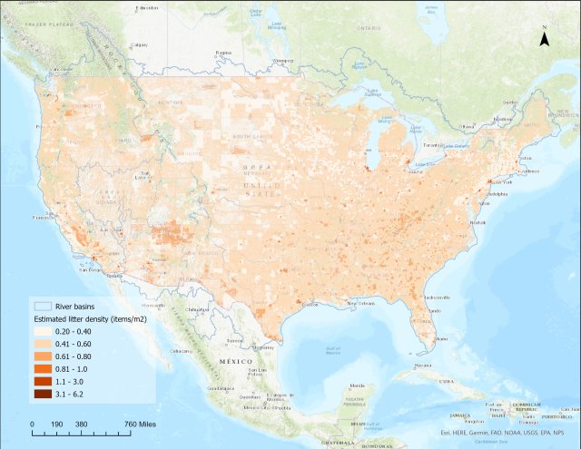
Escaped Trash Risk Map
The EPA's Trash Free Waters program has mapped estimated escaped trash density on land and at risk of getting into waterways in its Escaped Trash Risk Map, which displays trash density across the United States as of September 2024.
The map was developed with the University of Georgia and the Sea Education Association.
“Escaped trash” are materials like plastic cups and bags, paper products and other solid materials that have been littered intentionally or that have gotten into the environment because waste systems did not contain them securely. This tool is designed to help local governments and communities identify areas with an estimated high-density of escaped trash so that increased street sweeping, additional public trash cans, adopt-a-street initiatives, or other potential interventions can be evaluated for their usefulness in addressing the problem.
The resolution of the map shows estimated escaped trash counts at the one square kilometer level. Estimated escaped trash counts, item types and material type distribution are viewable for each U.S. river basin. To gauge the risk of escaped trash entering waterways, areas that intersect floodplains can also be viewed. The escaped trash density estimates serve as a ‘risk map’ of what escaped trash is estimated to be on the ground and at risk of getting into waterways. The model does not account for illegal dumping, street sweeping, cleanup efforts or other local factors.
Locations and summary data on microplastics in freshwater systems across the U.S. are also displayed in the map. Data are insufficient to estimate microplastic concentration in all U.S. waterbodies.
See a more detailed description of the Escaped Trash Risk Map (pdf) and the model underlying what the map displays.
Trash Free Waters is planning on establishing an Escaped Trash Monitoring Network to gather data to update the map for 2025 and beyond. Please sign up here if you are interested in potentially participating in this monitoring network.
Please use the form at the bottom of the Trash Free Waters Contact Us Page if you have any questions about the Escaped Trash Risk Map.

