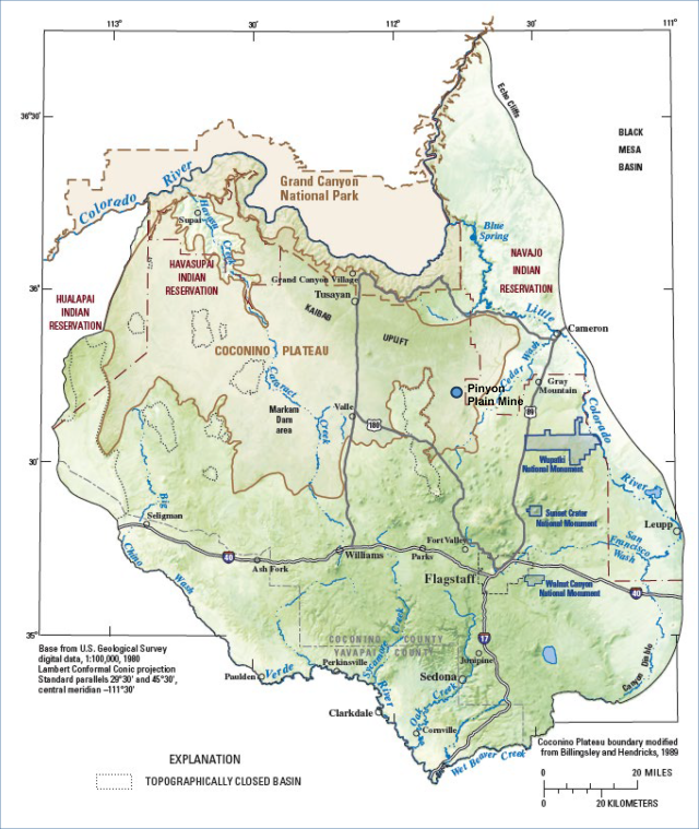
Pinyon Plain Mine, Coconino County, AZ
Introduction
In a study conducted by EPA, researchers found that there is potential for the uranium mining operations at the Pinyon Plain Mine inside the Kaibab National Forest to contaminate local and regional groundwater resources which are vital to the Havasupai Reservation’s water supply.
More evaluation is needed to understand the extent of aquifer connections, the direction of groundwater flow, and potential impacts to groundwater at the Pinyon Plain Mine site.
Background
Pinyon Plain Mine is an active uranium mine inside the Kaibab National Forest, located about 40 miles southeast of the Havasupai Reservation in Arizona. In December 2023, operator Energy Fuels Resources (EFR) began actively mining the site.
The Havasupai Tribe expressed concern that mining may contaminate groundwater resources that supply drinking water to the reservation. The Tribe requested assistance from EPA to evaluate the threat to groundwater. EPA, using the agency’s Office of Research and Development (ORD), then conducted a technical study. This report details the study’s findings and recommendations.
Study
The study relied on an analysis of scientific literature, including Arizona state and U.S. government agency reports and publications, Havasupai Tribe hazard mitigation plans, website information, and technical reports commissioned by EFR to prepare this study report.
The report focuses on three research areas:
- Focus Area 1: Independent hydrologic analysis of the flow between the shallower local C-aquifer and deeper regional R-aquifer at the Pinyon Plain Mine.
- Focus Area 2: Updated analysis of the risk of groundwater contamination resulting from operations at the Pinyon Plain Mine.
- Focus Area 3: Evaluation of wells to monitor water quality, groundwater level, groundwater flow directions, and aquifer connectivity.
Results
The study found there is potential for the uranium mining operations at the Pinyon Plain Mine to contaminate local and regional groundwater resources vital to the Havasupai Reservation’s water supply. However, further investigation is needed to understand the extent of aquifer connections, the direction of groundwater flow, and potential impacts to groundwater at the Pinyon Plain Mine site.
Some key study findings include:
Hydrologic Analysis
Although the shallower C-aquifer and deeper R-aquifer systems are separated by 2,000+ feet of rock layers, numerous studies strongly suggest likely connectivity between the two aquifers due to extensive fractures, faults, and other potential pathways. However, the rate and volume of groundwater flowing through these potential connections requires further investigation.
Potential for Groundwater Contamination from Mine Operations
Contamination of groundwater appears unlikely during normal mining operations, as long as the groundwater entering the mine shaft is not permitted to accumulate underground, the holding pond liner does not leak, and the mine site is sloped toward the pond to eliminate offsite runoff. However, it is unclear how groundwater flow patterns and the potential for contamination may change once active mining ceases and shaft water stops being pumped to the holding pond.
Evaluation of Monitoring Wells
The U.S. Geological Survey (USGS) maintains one well at the mine, completed in the shallower C-aquifer. In addition, three monitoring wells are installed in the C-aquifer and a fourth well is completed in the deeper R-aquifer. This fourth well is intended for both water supply and water quality monitoring. With the existing monitoring wells, there remains significant uncertainty about the groundwater flow direction, flow velocity, and potential connection between the two aquifers. The report concludes that these uncertainties can only be addressed by drilling additional wells to collect more data.
Recommendations
The study identified areas for further analysis and monitoring for potential groundwater contamination from mine operations.
Additional Wells
Although existing research strongly suggests C- and R-aquifer connectivity, EPA researchers conclude that more monitoring data from new wells could help us better understand these aquifer connections. Resolving the direction and rate of groundwater flow and quantifying how the contaminants flow in a single aquifer requires the use of at least three wells. EPA researchers recommend installing three new wells each in both the C- and R- aquifers (for a total of six wells).
EPA researchers also recommend placing two new wells in the low permeability layers that separate the shallow and deep aquifers. Drilling these wells would provide an opportunity for additional testing to determine aquifer properties and connectivity.
Additional data should be collected during well drilling to better understand characteristics of the rock layers. Geophysical measurements would help locate and describe faults, fractures, and other structures that might influence groundwater flow. Following well installation, aquifer tests are recommended to further determine aquifer characteristics and the potential for connectivity.
Additional Data/Sampling
Further evaluation of fractures at the site as well as the permeability and solubility of the ore body could also help understand the potential for vertical flow of contaminants between the C- and R-aquifers.
EPA researchers recommend analyzing additional samples from USGS wells in the area and mineshaft water. These samples could help evaluate current uranium concentrations.
Sampling for human-made contaminants such as Per- and Polyfluoroalkyl Substances (PFAS) and pharmaceuticals and personal care products (PPCPs) in the two aquifers and the mineshaft water could provide insight into potential contamination from the surface or from lateral groundwater inflow to and away from the mine. Data from these human-made contaminants could complement periodic assessment of other water quality data, such as uranium and arsenic levels, at existing wells and wells recommended for installation near the mine.
New monitoring wells should be periodically sampled for uranium and other compounds that provide information about the flow direction and flow rate of compounds possibly coming from the mine site. Sampling of these wells must be a long-term commitment (possibly years to decades) because of the comparatively long times it may take for pollutants to migrate downgradient.

